Nevada and California
Thursday October 12th until Tuesday October 24th 2017
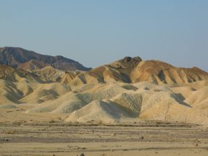
Death Valley
Wednesday evening we eat outside and we admire the beautiful sky, filled with stars. After a good night’s sleep, actually we always have one, we wake up Thursday, October 12th at 7 am. The Sun is shining and the thermometer shows already 72 degrees so we eat outside before leaving this great National park. The closer we approach Las Vegas the more traffic. It’s hard getting used to this traffic after the quiet roads we drove. I direct Dick to the wrong way and the result is that we have to cross all the city and over the Strip. Every hundred yards is a traffic light, always on RED, but finally, after a lot of traffic jams, we arrive at Road Runners RV park at 12.15 pm. Quickly we have a nice spot.
We stay for three days because then it’s cheaper. We are not in a hurry and consider this place always as a resting point on our trip. Offcourse I’m doing laundry, write for the website and Dick is selecting pictures. I’d rather read my books because I just exchanged some and they are waiting for me to read. Today we have a leftover day so we don’t go out for dinner but it is great to stay outside the RV and the food is good too. We still need much sleep because even when we don’t go late to bed, around 9.30 pm, we don’t wake up before 8 am without our alarm clock. The showers at this campsite are great and a welcome change with our own, navy shower in the RV. Although it‘s only 68 degrees and still cool, the sun warms quickly in the morning.
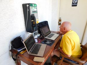
Dick is going to publish, he’ll do it in the campground office because the Wi-Fi is not so strong and I sit outside in the sun to make our English translation. Around noon the result is that I’m like a freshly baked bun and Dick exit the office as an ice cube. Always that freezing air conditioning. After some coffee and a shower we take the bus to the Strip. Unfortunately this time the driver is relentless. If we want a senior card, we have to show a special RTC senior identification and of course we don’t have that. We are not from Nevada. So we have to pay the full price for a ticket, $ 5,- but that is still much cheaper than if you buy a ticket on the Strip for $ 8,-
# VEGAS STRONG shirt
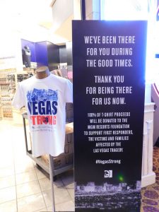
We get out the bus at Mandalay Bay and are not the only ones. Many people pay respect to victims of the horrific shooting a week ago. The billboards are full of texts and prayers. The windows from where the shooting was at the festival, on the opposite side of the road, are covered by banners with “# Vegas Strong”. Offcourse there are also candles and texts in memory of the many victims. The music festival “Route 91” is still hermetically sealed off. Lost in our thought we walk through the many casinos where everyday life started again. Only the T-shirts and many texts with “# Vegas Strong” are everywhere. Every now and then we try a slot machine but we never win. Also walking around the casinos and looking at people is enjoyable. Just before 6pm we arrive at our favorite restaurant “Outback” where we get a table at the window, enjoy the view over the Strip and of course the delicious food.
When we walk slowly back in the evening, it’s considerably busier than some weeks ago. It cools down quickly and we are happy to be in the bus back home. Saturday October 14th is really a day to idle or poke around. I complete my translation so Dick can publish soon and thereafter I’m searching in the cabinets to look for what we may take home. I end up with a bag full of clothes we take with us, better leave them at home then in the filled up RV. A second bag will contain other superfluous things which also can better stay at home. Very late we consider that we need to extend our RV insurance so we mail Seabridge to arrange that.
Website works
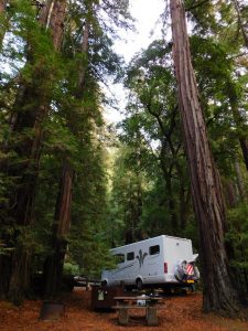
At 6 pm we shower and walk to Sam’s Town, where my players card, never used to gamble, give us a great deal because we have each $ 5,- discount on the buffet. There aren’t so many people so we do not have to stay in line and may proceed immediately. The food looks delicious, there is plenty of choice and it tastes good. Fortunately, my stomach isn’t so big and the look of the many, really fat people make you eat less. After walking around in this casino looking at the gambling people (actually they never win some) we go back to our RV. Doing nothing is also tiring. After another laundry in the early morning, so we leave Vegas clean, we need to do some shopping, fill up with diesel and propane and withdraw money before we really can leave Vegas and head to, yes again, Death Valley. On our way to the East Sierra this place is, after all, a natural overnight stay. This time we put the RV on the campground at Stovepipe Wells.
It is really quiet here. Except us, there are only a handful of RV’s. It is also very hot when we arrive, 98 degrees, so Dick put the awning down. Unfortunately, it gives us no benefit because the sun is too low but the refrigerator exhaust is in the shade. Because it is too hot to sit outside in the sun, we walk around.
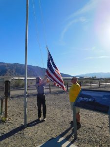
Helping the Ranger with the US-Flag
Near the campground is a Ranger Station and there we hope to get a stamp in our National Park Passport. Unfortunately the stamp is broken, a new one is requested, so we will have to do without it. But we can help the Ranger lowering the US-flag, which, of course, never may hit the ground.
When the sun disappears behind the mountain ridge at half past 5 it is pleasant outside. It’s still 77 degrees.
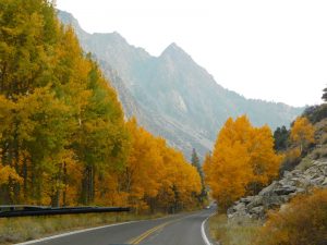
After a good breakfast we leave Death Valley on Monday morning. Offcourse we first chat some time with our neighbors from Oregon. We know the road but never drove it in this direction, to the West. It’s beautiful to cross the rugged ridges and drive through the lonely desert around us. We ascend and descend and ascend and descend, it doesn’t stop. Our brakes have to work to their limits, particularly after a 9 miles long descent with 9% slope. You really smell the brakes.
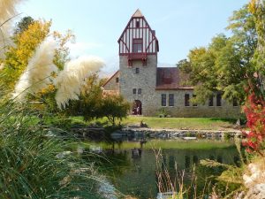
Fish Hatchery building
In Lone Pine, the sky is veiled by the smoke, with the result that Mt. Whittney the highest mountain on the US continent (excluding Alaska and Hawaii), is blurred. We drive on the US-395, one of the beautiful roads through the Eastern Sierra Nevada. Nearby is a historic Fish hatchery, a beautiful building which can endure the ages. Unfortunately this doesn’t count for the hatchery, this one don’t exist anymore after a mudslide in 2007. After fueling up in Bishop we look for a campground. Our Good Sam book indicates that there is a BLM campground near Horton Creek. But this place is not so easy to find, due to some road closures, but after asking and driving around, we find the campground in the middle of the mountains, it’s a nice spot.
A short time later we sit outside but when the sun disappears behind the high mountains that surround us, it is directly cold outside. Although we are at an altitude of 4930 feet, not so high up, the clear sky makes that it cools down very fast.
When we wake up at 7 am next morning it’s warm inside our RV. The heating ignited early morning. Outside it is just 42 degrees. Fortunately, it doesn’t take long before the sun get over the mountains and the first rays warm our RV.
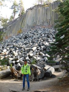
Devils Postpiles National Monument
Before we leave, we’ll look at the route and the weather. The forecast looks stable so we decide to make a trip to Devils Postpiles, a special rock formation and National Monument near Mammoth Lake. It’s good that it’s beautiful weather when we drive the steep mountain road, pin, after pin, after pin and go higher and higher up into the mountains above Mammoth.
At 9190 ft we arrive at the Mammoth ski arena. Unfortunately, there is no snow because I would love to ski here. After leaving the skiing area, we drive a narrow one-lane road, descending steeply down at the other side of the mountain. Fortunately we are early in the morning, 9.15 am, so there is no upcoming traffic, really pleasant on this narrow road with deep precipices. In the Valley, at 7500 feet, we soon find the car park. A trail leads us to the basalt columns of “Devils Postpile”. Along the way down we saw some campgrounds but all of them are already closed for the season so it’s good that we did not come here last night. It is freezing cold, around 40 degrees and I regret that we only put on a hoodie and long pants and no jacket, but the trail isn’t so long so after fifteen minutes we arrive at the foot of the 60 feet high Basalt columns. All though this rock formation with 5 to 7-sided vertical columns is pretty impressive, I pictured it taller.
After quite some time walking and looking and making pictures we walk back and return over the narrow, steep, mountain road. Regularly Dick has to turn aside to the steep side of the road, giving priority to oncoming traffic. Sometimes with tremendous speed they drive around the curves, not giving priority to us, climbing traffic. I give a sigh of relief when we arrive at the skiing area where the road widens. After descending the mountain, we continue our drive on US-395.
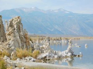
Tufa’s in Mono Lake
At the Visitor Center we took good maps so we can find our way to the Tufa’s in Mono Lake. It is awesome to walk along this lake (2 to 3 times saltier than the Pacific) and we admire the Tufa formations. The Tufa’s are formed when calcium out of a fresh water source contact the carbonate out of the salt water. The calcium carbonate forms the Rocky towers you see along the coastline. This Lake was seriously threatened by the State of California. They took all the water from the mountains for their own use. Committees took action for many years and managed to keep water for Mono Lake. California now only takes 80% of the water supply from the mountains. This makes, along with a winter with abundant snowfall, that the water level in Mono Lake increases. All this we learn when we look at a very interesting documentary about Mono Lake in the Action Center in Lee Vining.
Around 3 pm we leave Lee Vining to find a campground in the National Forest on our way to the Tiogapas, but all campgrounds are already closed for the season. October 15 is a magical date and end of the camping season.
Aspen trees near Silver Lake
It forces us to drive back to Silverlake where, amidst the beautiful colored yellow birch trees, we find a forest campground still open at an altitude of 7200 ft. Now we are surrounded by the high mountains of the Sierra Nevada and it’s cold, very cold, outside. At night the temperature drops to freezing and in the morning everywhere it’s white from the frost. Here it’s winter. Fortunately, the sky is still steel blue and the sun shines on the mountains when we wake up, so the Tioga Pass we want to drive to San Francisco (better than having a 100 miles detour) will be still open.
After checking our mail in Lee Vining, we climb Tioga pass, where we arrive at 9.15 a.m. at almost 10000 feet. It’s obvious that one of these days this road will be closed because all the campgrounds and lodges along the way are already closed.
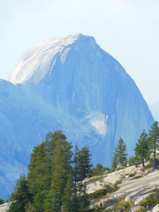
Yosemite Half Dome view from Olmsted
The ranger thinks the road will be closed before the weekend because of the weather. Snow is expected. When we stop at Olmsted, a viewpoint with the bald smooth rocks and the Half Dome, we see huge clouds of smoke in the distance, caused by the fires in the southern part of Yosemite, near Wawona. That’s why the view around is hazy. Around noon we are in Yosemite Valley. It is very busy here, all parking spaces are full and everywhere are people. In a traffic jam we drive around Yosemite Village, where climbers search for their gear so, in these last sunny autumn days, they can climb the sheer rock walls of El Capitan. All the campgrounds are full, only in Wawona in the South or Hodgdon Meadow in the North are still places available. We decide to drive to the North, it’s closer and further from the fires and Yes, even at 3 pm we find a beautiful spot on Hodgdon Meadow Campground.
It is difficult to level our RV because the ground is very uneven and this campground has only slopes but Dick has developed an art to level our RV, even without levelers. We notice that we are on a significantly lower altitude, almost 4900 ft, because the temperature increase and it’s now 75 degrees.
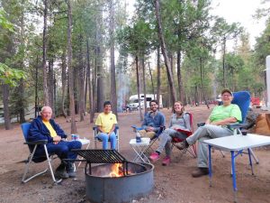
Together at the campfire
Even when the sun disappears behind the mountains it’s very pleasant outside next to a wood fire because there is practically no wind. Together with Ralf and Rosanne from Amsterdam and our Camphost Cindy we enjoy the campfire and a delicious glass of wine. Thursday October 19th, after breakfast, we leave Yosemite. At the entrance of the park we see the sign that at 5 pm the Tioga Pass will be closed. We are just in time. After a long descent, passing the dreary trees, victim of forest fires last autumn, we arrive in flat country. Every piece of land here is planted with fruit trees and grape vines. No wonder this dry California take so much water from the mountains.
In an almost a straight line we drive to the West and in Antioch, a small town not far from San Francisco, we find the last spot on the Fairgrounds campground. The rest of the afternoon we do our administration and I also skype with my Auntie Ank before she goes to bed. There is a 9 hour time difference with The Netherlands. Because of the cold wind so it’s not agreeable outside. Tomorrow we drive to our storage to do the paperwork so we can storage our RV there. We don’t leave Antioch early morning because the American insurance mailed us that they need all kind of papers and pictures of our RV and we want to do that first. Our current RV insurance company no longer exists and cannot be extended. We really don’t like this !!!! But we have to deal with it.
Treila, Harbor Bay Storage
Finally we leave the Fairgrounds in Antioch and emerge into the busy traffic around the Bay Area of San Francisco. There is a lot of traffic and people drive aggressive and speed. You need eyes on all sides. At half past 11 am we arrive at Harbor Bay Storage in Alameda where we are warmly greeted by Treila, the manager. Three years ago we met her and stored our RV here and thanks to Treila, again a spot is available. We chat a lot and have fun and Dick shows Treila the art of Geocaching, because we want to search our third “Cache Cross America”, California. It’s hidden near Palo Alto. At 1 pm we leave the storage after saying goodbye to Treila. Everywhere is a traffic jam, often 7 lanes width but eventually we arrive close to our cache.
Unfortunately, it is near the huge Google complex and wherever we look, there are cars parked and nowhere is a place to put our RV. After some time driving around, we find one place to park and we start our search. It’s a long walk and we look more difficult than necessary, but finally we find the cache.
“California” we got you. Riley and Karen found this one too because their name is in the logbook. Earlier at the storage, Treila and I looked for places in this neighborhood to stay overnight and we drive to a public park, high in the mountains. I should have known that the road would not be easy to drive when I see “skyline” and later “alpine” road on the map. Indeed, we drive on a really winding mountain road with deep and steep precipices. The public park is nice but too expensive ($44) so we continue our drive over the coastal mountains to Redwood State Park in La Honda. The road here is even more narrower with a lot of pins and steeper than what we already have driven so I hope there is a spot in this park. It’s already 5pm.
Redwood State Park Campground
We’re lucky because after driving around, only RV’s until 24 feet are allowed and our RV is 24’5” feet, we find an empty spot between the tall Redwoods. Although it is not my first choice to stay in between these tall trees, it’s cool and there is a lot of moisture, this place is very impressive by the huge and tall trees. The temperature is not so bad as long as you don’t sit outside. Dick prepares our meat on the grill outside and we eat inside. And of course we raise our glass on Riley’s birthday. Saturdaymorning we see that the campground is completely filled up, so yesterday we got really lucky with this place. It is now 44 degrees but that’s because the Sun cannot penetrate the trees.
However we can change our long pants and hoodie a little later when we leave the narrow mountain road and arrive at the rim drive, we are warmed up by the sun. Our “Hakuna” (navi tool) brings us over all kind of winding roads. The many cyclists here are surprised. We think no other things drive around here than cyclists and small cars, certainly no RV’s. Finally we arrive at Palo Alto and moments later we take Dumbarton Bridge over the bay. It should be a toll bridge but we only see toll booth at the other side of the road. Possible it’s the same as the Golden Gate bridge, you only need to pay toll if you drive into the direction of San Francisco. Near Oakland is Anthony Cabot campground. I think it’s nice to stay here two nights. I should have known better because it is Saturday and after driving 8 miles over a narrow mountain road we find out that the campground is full. So we continue our drive to Antioch.
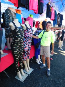
Flea Market in Antioch
On the fairgrounds is a flea market and we have some trouble to reach the campground. But that’s probably the reason that there is still one spot. We may stay for two days. After a cup of coffee, especially Dick earns that with all those mountain roads, we walk around the market. Except a lot of used stuff, Dick call them rubbish, there is also new stuff for sale. I find a new case for my IPhone, urgently needed because the old one really falls apart. We also cycle around to find a laundromat, we want to use tomorrow. Sunday morning we sleep until 8 am and after fueling up we drive to the laundromat. The neighborhood is not really great. A lot of people loiter and everywhere is the smell of hashish. But the laundromat is quiet and the washing machines wash fairly clean so at 11 am we finish and our closets are not empty anymore.
The rest of the day we pack our bags for Holland, I clean the empty fridge and Dick polishes the bikes and our bike rack. Tomorrow we put them inside our RV. At least we are ready for our journey back home. Bags are packed and tomorrow we only have to dump our grey and black water.
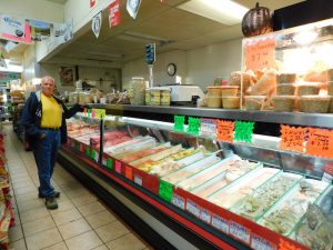
Collecting diner in Mexican Store
We have no food anymore, only a piece of bread for tomorrow, so we walk into the city to a Mexican grocery store. Not only at the flea market, Mexico was all around and everybody spoke Spanish, also at this place you think you are in Mexico. There is also a restaurant so with some help we order food and soon, with Mexican food, we walk back to the RV. The food is good. So good that next time we will take again food from this place. We go to bed in time because tomorrow at 6 am, our alarm clock will wake us up.
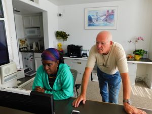
Monday October 23rd we drive at sunrise because we want to be early in Alameda and after putting our RV in the storage we take the public transport to our hotel in San Francisco. The Aida hotel is located on Market Street, very conveniently because it’s just a few 100 yards walk from the BART (Bay Area Rapid Transport system) and it also goes directly to San Francisco Airport within 45 minutes. Very easy. Early afternoon we are in our hotel. The room is super simple, the bed very narrow, not what we are used to in American hotels, but we can open the windows, there is no airco (we love that) and the people are very friendly. We walk around in the area, eat some at the Cheesecake Factory on the 7th floor of Macy’s, a well-known department store and then we enter the new Apple store here where we admire the newly announced IPhone 8.
We don’t see much difference with former editions, a lot of people wait for the IPhone X, announced for November 3rd. End of the afternoon we walk back to our hotel and on a TV from the ‘70th we look an episode of criminal minds, you see them 24 hours a day.
A moment to rest in SF
Tomorrow October 25th we fly back to the Netherlands but today, the 24th we still have a day in San Francisco to look around. We don’t want to see the standard tourist attractions but choose a walking tour lead by geocaches and again we come to places we didn’t see before. Around 5 pm, we walked almost 9 miles, we end up at Moo’s, a small restaurant in Grant Avenue. Several times before we had a burger here and once again this one has a “super” quality. We cannot remember where we ever have had a better hamburger. Then we walk back to our hotel and slightly tired, all together we walked 11 miles, we go to our bed.
November 4, we hope to be back in the land of the “unlimited possibilities”.