Nevada and Utah, Tuesday november 14th until november 25th 2017
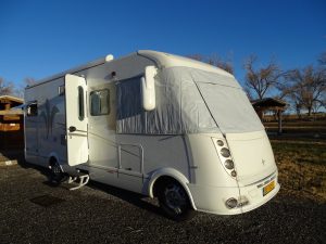
Insulation on front window
During the night it’s colder so we attach our insulating blanket in front of our window. It’s not really a lot of work and it makes the cold stopped, which otherwise, due to our huge front window, comes inside. Because we only tried once at home how to fix this, the first days it take quite some time to attach this blanket. So Tuesday November 14th we don’t leave this beautiful Bruneau State Park before 10 am (then we also took fresh water). It is only 40 degrees and the meadows are white so we did well yesterday to install our insulating blanket. After today that will be needed every evening, considering the season. In our RV it’s never ever cold because we have a regular heating on propane, it works like central heating, is very comfortable but also very propane consuming. And next to this is another heather, working on diesel from our tank, that one gives a burst of heat. You often find these on big trucks. This second heater is very pleasant, especially if you come back from a long walk this time of the year.
On the road again
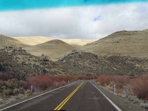
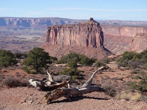
We drive South, to the State of Nevada, over very lonely roads, through the great nothing. The high plateau we cross is bare and there is nothing, only every now and then we pass a farm and we see some cows in the bush. Luckily, the plateau pass into a narrow gorge which makes the landscape more attractive and at noon we cross a time zone and arrive in Western Pacific Time, so we have an extra hour today. Slowly we leave the high plateau and the mountains and descend to Elco in Nevada where we stay overnight at Walmart. Although we think we already drive through a remote area, the next day we arrive on highway 50, also called the “Loniest road in America”. That’s because in 1986 Life magazine told that no attractions nor interesting things along this road were to be found and that, if you wanted to drive this road, you needed to have survival skills. But we find it a nice road, quiet and with a great diversity. Again we drive over large Plains alternate with high mountains. A road, to stop now and then and to look for caches. Even a coyote is here but because of the sage brush we cannot make a good picture. At a parking where we stop to look for a cache, on Little Antelope summit (almost 7540 feet), we see a Chevrolet Silverado Pickup. It looks that the driver fell asleep, so softly I walk along the car on my way to the cache.
After finding the cache there is still no movement in the car so I look through the window inside. Directly I have a flashback from the time I was a trainee at the murder squad of the police in the Hague. There we constantly had to recover dead people and this guy looks like those. Clearly, he isn’t alive for a couple of days if you look at him. I ask Dick to come to look too. While I focus on the dead swollen face of the man Dick find out that the front of the man is covered with blood, a shot incident? Directly we jump in our car and drive off to Ely, Nevada, the nearest town, to inform the sheriff. Ofcourse in this remote mountain area we have no service. Luckily after 10 miles a car is leaving a ranch nearby and we stop them at the road. They have a phone with service and we are able to inform the sheriff of our discovery.
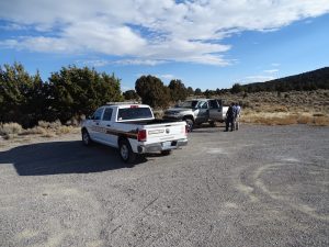
With the Sheriff on the scene
We give the coordinates but the sheriff asks us to wait where we are. The distances are great and Ely is 40 miles away so 45 minutes later the sheriff arrives. We talk and follow the sheriff to the place where we found the dead man. Since Friday, so five days ago, he is missing and it is clear that the man shot himself. He borrowed a gun from a friend.
After we write down what we know, we say goodbye to the sheriff. Unfortunately we are not allowed to have another look into the car. Behind the casino in Ely we find a nice spot to spend the night at the parking lot of hotel Nevada. We talk a long time together about this strange find. It’s really the “Loniest road”. If someone can sit dead behind the steering wheel for 5 days on a parking lot along the way.
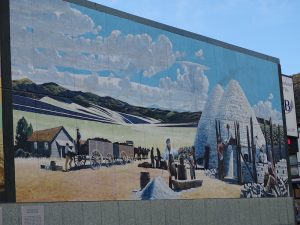
Wallpaintings in Ely
We walk through the old mining town of Ely, of course we also walk around in the casino and eat some at Denny’s (not really tasty) before we go to bed. We don’t have a sound sleep, at least I don’t. The face of the man we found in the car regularly returns on my retina. Thursday, November 16th we wake up early. Downtown Ely, in the shelter of the houses, it’s pleasant but once we leave town behind us and drive on the large plains it’s getting cold and a chilly wind is blowing, we are at an altitude of 6560 feet.
Yet we climb higher and higher and also descend again. After passing some passes we arrive at Great Basin National Park. We want to visit the Lehman Caves and at 1 pm there is a tour. So we first look for a place on a completely empty National Park campground and search some caches. Near one of the caches is a man, handmade and very lookalike and I am scared. It turns out that the founding the dead man still has an impact. Just in time we are back at the Visitor Center. If you think that on such a cold, cloudy, weekday few visitors will visit the caves, you are wrong because 15 people joining the two-hour tour.
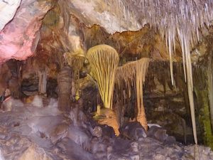
Shields in Lehman Cave
Ranger Becca tells much and good and it is enjoyable to walk around with her through these caves. Although the cave is beautiful and has special formations such as “shields”, a kind of round plates, with draperies and stalactites, this one doesn’t end in our top ten. Around 3 pm we drive back to the campground, it’s at an altitude of 7320 feet. The sky is grey, an icy wind is blowing and black clouds hang around the mountaintop so we’re putting our insulating blanket in front of our windshield. Although I always like to have a wood fire and there is sufficient wood out here, we don’t make a fire because of the temperature. Inside it is really more pleasant. Friday morning November 17th the weather is weird because blue sky and sun alternate with snow showers. Soon after breakfast we leave Great Basin National Park and within 20 minutes we arrive at the border with Utah and it’s mountain time, so we lose an hour. During this trip we have a lot of time difference. Because we descend quickly to the large Plains, we leave the cold behind us and even the Sun breaks through, it is extremely pleasant, time to wear our short pants again.
Even the wind, blowing strong over the vast plains, feels warm. Although we may not enjoy this temperature for a long time because after noon, when we arrive in Hinckley, rain and even snow is falling down. However, we want to continue because we decided that the caches of Utah Geo Tour will decide which route we take to Page, Arizona. Any county of Utah has 5 caches hidden and when you find at least three of them, you earn a patch. And if you have 10 counties, you can even qualify for a special golden coin. What is more fun than trying to find a lot of these caches on our way south. At this moment our friends Riley and Karen are still in Africa and not back in Page before November 26th.
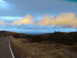
Rain or Sun above Great Basin
It means that we drive endless unpaved roads, going through snow storms, climbing high hills and have miles and miles of detour. But we have fun and see places where otherwise we should never come. Unfortunately the weather is not really nice and the rest of the afternoon snow and pouring rain exchange and there is a severe storm. But we see the barren plain where during the second world war the American natives, born in Japan, were interned for several years. In contrast to Manzanar, CA, in the Eastern Sierra Nevada, also an internment camp, where barracks and a museum expose this period, here is nothing to see except a Memorial Sign and of course our Utah Geo Tour cache.
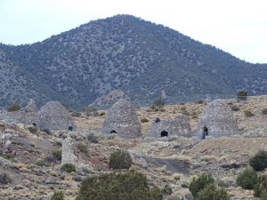
Ruins in Ghost Town
We drive beside endless long trains, over bare Plains where wind and snow have a free game and eventually we arrive in Frisco, Utah, a ghost town high up in the mountains where nobody lives and nothing except for some brick kilns and a partly collapsed ruin survived. Unfortunately the place is to cold and to inhospitable to stay overnight so we drive back to Milford, a small town in the valley at an altitude of 4980 feet. We saw, on our way to Frisco, UT, this City park where we can spend the night. Just before it’s pitch black we arrive. And after fixing our insulating blanket, it’s now 32 degrees, we relax in our pleasant and warm RV. Today we drove 230 miles. When we had driven directly from Great Basin National Park to here, we made less than a third of this distance. But then we would not have seen so many beautiful things.
It was cold last night
During the night it freezes a lot and on Saturday morning we can pick the icicles of our RV, but the Sun is shining again and there is no cloud in the steel blue sky. What a great winter day. Soon the temperature rises from 45 till 59 degrees and we walk around in our T-shirt. After filling up with diesel, we look for a laundromat because we have to wash our clothes and bedding. At 1 pm everything is clean and dry and we decide to drive back to the City park and stay another night. It is not only a great (free) place on the edge of the town but we also can work on our website and maybe Dick can publish. Not a bad idea because we are already travelling around for two weeks and still we did not publish. While Dick is looking for pictures, I walk around town, do some shopping and enjoy the warmth of the Sun. The day flies and before we know it’s dark again. We don’t like it that, this time of the year, the sun set at half past five. It promised to be a cold night because there are no clouds and the wind is blowing pretty hard.
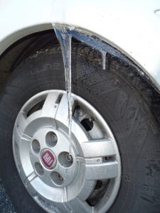
And it’s cold that night. When we wake up on Sunday morning November 19th we have no hot water. The low temperature (it was only 10 degrees F) and the icy wind has frozen our hot water pipe. We cannot take a shower and have to wash ourselves with a washcloth and icy cold water. Then you really have a short wash. Fortunately, the sun shines and although some clouds appear in the sky, after a several hours drive, we notice that our waterworks thaw and again we can tap hot water. We drive along lonely roads with almost no traffic, look at Minersville Reservoir with a beautiful campground (good to know for next time) and arrive in the town of Beaver.
Empty box, cache is stolen
Our Utah cache is hidden next to the sheriff’s office but stolen, unfortunately. I cannot report this because the sheriff’s office is closed so we have to find a third cache, high up in the mountains on the Utah-153. The road up is still open and we hope we can descend on the other side. As we get higher and higher there is more snow but only on the dark side of the road are some icy spots. Dick says we can still ride the road. We cannot say that about the last 1 mile uphill. We already passed the 9840 feet.
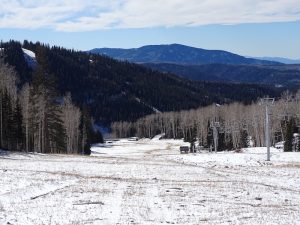
On the piste to the cache
After a few yards the RV slide on snow and ice and Dick decides to slowly back down so I get out and walk up the slopes, it is more climbing up because the slope is pretty steep. Fortunately, there is not yet a lot of snow on the slopes, so I don’t sink into the snow when walking. Finally I am at the top of the ski run near the end of a chair lift at an altitude of 10820 feet and I find the cache. There is a piece of hardboard on which I want to descend but then it turns out that there is really to little snow and to many rocks on the ski run so I run down the ski run and 35 minutes later I am back at the RV.
We continue to drive this high altitude road through the snowy mountains until we reach a spot so filled with snow and we really cannot drive this road anymore so we turn and drive the road back we came up. We have to do a detour, that’s it. After some time we arrive on the Utah-89 and follow this road through mountain gorges to the North. All the campgrounds are closed and the race course in Marysville, Utah, is not really so attractive to stay overnight.
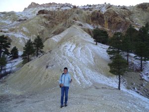
Candy Rock Mountain
At Candy Mountain, where yellow and brown colored hills dominate the landscape, we stop. We are allowed to stay overnight next to the closed resort. The owners just returned from a holiday and they give us power. Ofcourse we walk along these colored rocks. It is a weird landscape, almost otherworldly, it’s cold and everywhere is snow. We are at an altitude of 6250 feet. Just before dark we are back at the RV, completely numb because it freezes all over this place. Again our insulating blanket works good and it’s absolutely not cold inside our motorhome. In this remote place it’s dead silent (everything around is closed) so we sleep as roses. Monday morning we thank the owners of the resort for their allowance to stay here and drive through the magnificent Gorge to the I-70 where we stop at Fremont Indian State park.
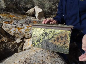
Prehistoric cache box
As we are seniors we only need to pay $ 4,- entrance fee and we may use the Wifi of the State Park. If we want to find the cache here we first have to solve a puzzle. Unfortunately the Wifi is very weak and has trouble to download the program we need to solve the puzzle, so the ranger give us some clues and moments later we walk through the State Park looking at the many petroglyphs on the steeply rising rocks. The petroglyphs were discovered when the I-70 was built and we enjoy them and walk some trails. Ofcourse we also find our cache. Finally we leave the park at 11 am and drive to Monroe, UT, where another cache is hidden in a canyon.
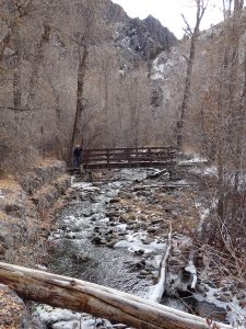
Winter in Monrovian Park
We slowly climb up through a very narrow gorge and after some puzzling and a beautiful walk along a mountain stream through the snow, we find the cache. It’s 2 pm when we arrive in Richfield, UT, where we can fill up with propane and diesel. Then we decide to drive to Salina where we stayed before and had great Mexican food. There is enough place on the campground nearby and after fixing our insulation (it takes no longer than 5 minutes now) the night is there and we walk to the Mexican where we enjoy our meal. Tuesday morning, November 21st , the sun shines when we wake up at seven o’clock. It’s only 41 degrees and there are still some clouds but it promises to be a wonderful day. Unfortunately, we have problems in reaching auntie Ank by Skype so early we leave and take the Utah-24 on a snail’s pace behind a huge flock of sheep.

Sheep, sheep and sheep on the road
This flock takes the whole road and during a few miles we drive behind them. We don’t mind because it’s funny to look at these white balls of wool in front of us, forced up by a man on horseback and at least 10 dogs. Still, if we are 2 miles further on the road and a Native squeezes simply through the flock with his large pickup truck, we follow closely because it’s also very sleep inducing to drive in a walking pace behind such a mass of sheep. Road 24 twists through the mountains and near Fish lake we really climb up. There are special tree species to admire at Fish lake, the Pando Grove. Ofcourse we want to see them and of course, there is another cache. At an altitude of 8950 feet we solve a puzzle and find our cache hidden between the Pando trees.
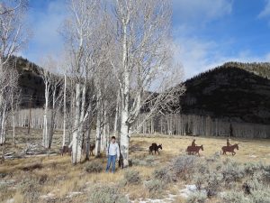
Pando Grove trees at Fish Lake
They look like birch trees but the stems and branches are different. They are monumental trees to see. After walking around some time we leave the beautiful alpine environment, it is 45 degrees, and we descend through the town of Loa, UT, to Torrey, UT, and arrive in Capitol Reef National park. The huge red rock walls here always amaze us. It is just noon so we will not stay here and drive further, over a dirt road, to Cathedral rock. Fortunately, before the road really is too rough and difficult for our RV, we find our cache. We enjoy the wilderness around us and the temperature because without any wind, and with lot of sun it’s at least 68 degrees. When we are back on the paved road our GPS again shows us a gravel road to Factory Butte.
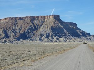
The road at Factory Butte
Dick looks at the road and says it’s OK to take this path so soon we drive through the great nothing. Now we’re really in the middle of nowhere, we see no other people and around us are only strange sand formations. After driving this unpaved road for miles and miles we finally find a couple of big rock formations where our cache is hidden. Before we turn around (Dick always does this faultless) we make pictures of the surroundings and enjoy the warmth of the Sun. We are so lucky with the weather, end of November. When we are back on the paved road and passed the town of Hanksville, we take a turn off to Goblin valley. There is enough place on the campground of this State Park and we take the disabled spot.
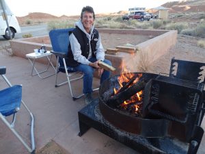
Finally a campfire
The sun quickly disappears behind the rock walls so we make a wood fire to warm us. Until all our wood is burned we sit outside and enjoy this great day. In the dark Dick prepare our steaks on the grill and we have a delicious dinner. The night is dark and the sky filled with stars and it’s quiet here in the middle of the desert. Wednesday november 22nd we wake up at 7 am when the Sun appears over the mountains. The weather forecast for the next few days is good so we can continue our way through this mountainous region of Utah.
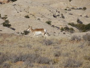
Pronghorn Antelope’s in Goblin Valley
Still in Goblin State Park we see a herd of Pronghorns next to us and after a short part of the I-70 we drive into the desert. Our Hakuna (Garmin Navi) thinks it’s a dirt road but we really see a paved road winding through the landscape. This “Moore Cutoff” road is beautiful, it’s wild and lonely. Here you are really thrown back on yourself. After a stop in Ferron, UT, where we chat with some folks at the local museum and admire the large furnace used for preparing the turkeys and hams for Thanksgiving, we have a delicious subway in Castle Dale before searching for more caches. Unfortunately, the last cache, hidden between a huge mass of rocks, we don’t find.
Over more than half an hour we climb the huge boulders and then, it‘s almost evening, we drive without success to Price, UT, where we spend the night at Walmart. The Sun is just behind the mountains and reflect beautiful in the windows. Ofcourse we walk around in Walmart. There is a lot to buy because tomorrow night Black Friday starts, a clearance sale of quite a few articles and therefore everything is set up for the huge amount of people they expect to come. After a few nights of quiet sleep, this night we regularly wake up. At first because of the hard honking trains, they don’t stop to warn that they are on their way and after the trains are gone there is a sound I don’t know but it’s very disturbing. It turns out to be a sweeper for the big parking lot and it goes on and on. Not really pleasant. We sleep again when this nasty noise maker is gone. After we wake up really rough on Thanksgiving day by our alarm clock, I like to Skype but auntie Ank is not online on her computer, we do some last shopping at Walmart and leave Price at 9am. It is really quiet on the road so we have all the time to look around.
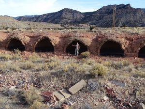
Coke’s ovens near Sunny Side
We are on our way to the Sunnyside Coke ovens, located somewhere in the landscape and before we reach them we also find a cache at an old Coral. Yesterday Dick twisted his knee and I fell down on my butt on the roadside so we don’t really walk great but finally we arrive at the Coke ovens. A beautiful view all those round ovens next to each other In the landscape, there are really a lot of them and in the past they serviced to the ore mining industries. It’s really great weather and there is plenty of sunshine. Fortunately, there is hardly any wind so the temperature rises to 68 degrees. After taken many pictures we drive on the narrow mountain road back to Utah-191 and eventually we arrive around two pm at the Courthouse Rock, a huge rock formation north of Moab, in the middle of nowhere.
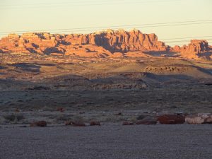
Nightfall – Courthouse Rock near Moab
There is a BLM campground and the sun shines very tempting, so we just need to look at each other to know that we will stay here tonight. The rest of the afternoon, after we find a cache, we are outside. I work on my laptop while Dick make all kinds of repairs such as the closure of the kitchen drawer that broke down. When the sun disappears behind the mountains, it’s now half past 4 pm, it is so cold that we have to go inside the RV. The OHV’s that cross around here, slowly return to their base. We sleep under a beautiful starry sky, only in the distance are lights, there where Moab is located. Finally I manage to skype auntie Ank on Friday morning, it’s amazing our Mifi works here. We leave this remote place at 9 am. There are a lot of cars on this dirt road. For many of them this “Black Friday” is a day off and the calm and sunny autumn weather attracts everyone to go out. Since we are close to the northern part of Canyonlands National Park we decide to go in. We have to drive part of this road anyway to find two Utah Geo Tour caches. At the entrance to Canyonlands is already a line. Not good because of the lack of parking spots in the park.
Canyonlands, Island in the Sky
After getting our stamp at the Visitor Center and looking at the movie we drive into the park. Despite the fact that it is not always easy to find a parking place we hike to several places where we have a look over the edge of the plateau. The plateau we are driving on is at an altitude of 6230 feet above sea level and deep down below us we see a landscape, sliced by canyons. No wonder this part of Canyonlands is called “Island in the Sky”. We’re lucky again with the weather because the sky is blue, the sun is shining, there’s no wind and it’s 69 degrees so we walk in our T-shirt.
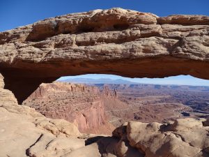
Canyonlands, Mesa Arch
The most beautiful walk is to Mesa Arch. From here, under the Arch, there is a beautiful view over canyons and rock formations. We don’t stop taking pictures. Eventually we leave this impressive landscape where the Green river and the Colorado river cut slices through the landscape over millions of years. After filling up in Moab, we go on, we have to because it’s already 3 pm so there is no time for bargain hunting on this Black Friday. We drive to the southern part of Canyonlands National park. 5 Mile before the entrance is BLM land, where it’s allowed to stay overnight.
Just before the sun disappears behind the mountains we arrive on the dirt road to Hamburger Rock. Everywhere the landscape is dotted with tents, there are many rock climbers here, but finally we find a reasonable spot amidst the Sage Brush. We just have time to fix our insulation and take a picture before it gets dark. The only sound around us are the cars on their way to their tents. I had no idea that amidst such a wild and unexplored area a few hundred people would spend the night. On Saturday November 25th we wake up as the first rays of sun appear over the mountains. This is a particularly pleasant place to stay.
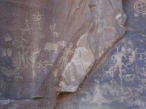
Petroglyphs, Newspaper Rock
Of course we have breakfast before we leave and at Newspaper Rock (the Navajo Indians call it: “the rock that tells a story) we look for our Utah Geotour cache. Yes, we were here before, in September, but then we knew nothing about this Utah Geo Tour thing. Oh well, it’s awesome to look at the rock walls with 2000 years old petroglyphs. Soon we find our cache and drive further, via Monticello and Bluff, where we fill up with water and then we go to Goosenecks State Park. It is now 2.15 pm, good weather and we decide to stay there. We find a beautiful spot on the edge of the Gorge where deep below us, the San Juan River meanders. After finding again a geocache we walk along the edge of the Gorge and watch the river deep below.
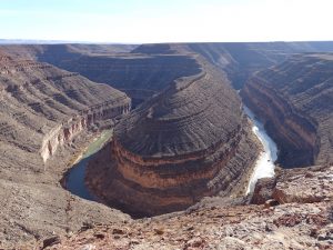
Gooseneck State Park, San Juan River
Then we sit outside our RV in the sun and write, read, talk and drink coffee. Dick is cleaning the windows in- and outside. It’s definitely not my job because when I clean them, there are more stripes than when I started. On the horizon we see the rock formations of Monument Valley. Again we stay at a beautiful and quiet place amidst awesome nature